California is free of all drought, dryness for first time in 25 years. Inside the remarkable turnaround


-
Click here to listen to this article - Share via
See more from the L.A. Times in Google Search. Set us as preferred
- California has zero areas of abnormal dryness for the first time in 25 years after an exceptionally wet holiday season soaked the state.
- Currently, 14 of the state’s 17 major water reservoirs are at 70% capacity or higher and wildfire risk is minimal.
- Despite the welcome relief, climate change is expected to intensify weather swings from heavy rainfall to extreme dryness in a cycle that can fuel catastrophic wildfires.
After experiencing one of the wettest holiday seasons on record, still soggy California hit a major milestone this week — having zero areas of abnormal dryness for the first time in 25 years.
The data, collected by the U.S. Drought Monitor, is a welcome nugget of news for Golden State residents, who in the last 15 years alone have lived through two of the worst droughts on record, the worst wildfire seasons on record and the most destructive wildfires ever.
Right now, the wildfire risk across California is “about as close to zero as it ever gets,” and there is likely no need to worry about the state’s water supply for the rest of the year, said UC climate scientist Daniel Swain. Currently, 14 of the state’s 17 major water supply reservoirs are at 70% or more capacity, according to the California Department of Water Resources.
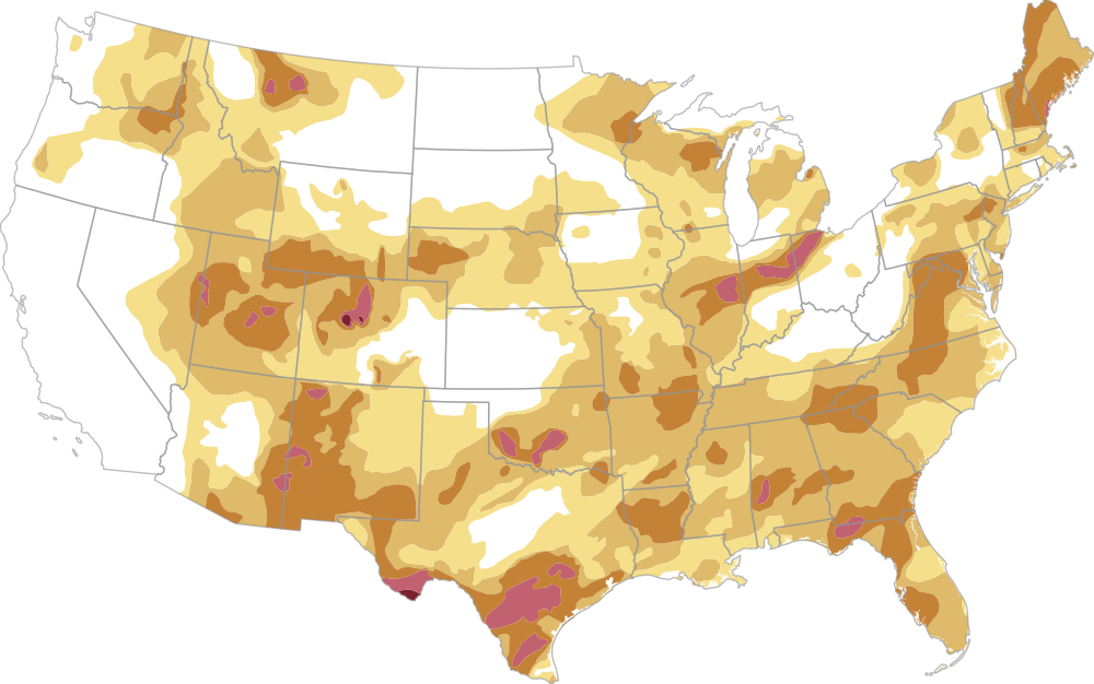
U.S. drought conditions
About 45% of the country was experiencing at least moderate drought conditions on Jan. 6.
Denver
Fresno
Las Vegas
Los Angeles
LOS ANGELES TIMES
California’s last drought lasted more than 1,300 days, from February 2020 to October 2023, at which point just 0.7% of the state remained abnormally dry, thanks to a series of winter atmospheric rivers that showered the Golden State with rain.
Before that, California was in a severe drought from 2012 through 2016.
But the last time 0% of the California map had any level of abnormally dry or drought conditions was all the way back in December 2000. In recent weeks, a series of powerful winter storms and atmospheric rivers have swept across California, dumping heavy rain that soaked soils, filled reservoirs and left much of the state unusually wet for this time of year.
“This is certainly a less destructive weather winter than last year was and than many of the drought years were, so it’s OK to take that breather and to acknowledge that, right now, things are doing OK,” Swain said. He noted, however, that “as we move forward, we do expect to be dealing with increasingly extreme [weather] swings.”

Scientists attribute these extreme weather swings to climate change, warning of intensifying “hydroclimate whiplash” patterns globally.
Though it may seem counterintuitive, climate change is forecast to lead to both more intense droughts and more intense episodes of rainfall. This is because a warmer atmosphere pulls more moisture out of soils and plants, deepening droughts. At the same time, a warmer atmosphere holds more water vapor, which is then released in fewer, more extreme rainstorms.
Scientists have coined a name for this phenomenon — the atmospheric sponge effect — which Swain said is “hopefully an evocative visual analogy that describes why as the climate warms we actually are likely to see wider swings between extremely wet conditions and extremely dry conditions.”
A key example of this effect is the weather pattern in the run-up to the devastating Palisades and Eaton fires last year.

The California fires erupted amid extremely dry conditions. UCLA scientists say extreme heat linked to climate change was a factor in the fires’ intensity.
In 2022 and 2023, California experienced extremely wet winters. Mammoth Mountain, for example, set an all-time record for snowfall in the 2022-23 season.
But then Southern California experienced one of the driest periods on record in the fall and winter of 2024, which enabled the subsequent devastation of January 2025’s firestorm.
“We didn’t even have to be in a notable multiyear drought to have that sequence of really wet to really dry conditions lead us to a place where the fire risk was catastrophic,”Swain said.
Recent storms have brought snow to the Sierra Nevada mountains, but the state’s snowpack remains below average. According to the Department of Water Resources, the snowpack now stands at 89% of average for this time of year.
Much of the West has seen warmer-than-average temperatures and relatively little snow so far this winter. The snow in the Rocky Mountains remains far below average, adding to the strains on the overtapped Colorado River, a major water source for Southern California.
Research published in the aftermath of the fire examines how this extremely wet to extremely dry weather sequence is especially dangerous for wildfires in Southern California because heavy rainfall leads to high growth of grass and brush, which then becomes abundant fuel during periods of extreme dryness.
Fortunately, California should be clear of water supply risks and wildfire danger for several months to come, Swain said, but in the long term, residents should expect to see more of this weather whiplash.
Times staff writer Ian James contributed to this report.


More From the Los Angeles Times


Podcasts

William Mulholland was the water boss who made L.A. possible. His reputation gave him unchecked authority as a dam builder. In 1928, that led to one of America’s deadliest disasters--and the question of whether it was a crime.

It started as a ploy to scare Texas out of redrawing its congressional map and ended with California voters approving a new map of their own, one that could hat could help alter the balance of power in Washington.
On this week’s episode of Boiling Point, Miranda Green speaks with Los Angeles Times climate reporter Hayley Smith about how AI bots are meddling in California’s clean energy policymaking.


